
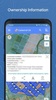


Kadastr UA is a comprehensive app designed to provide access to the public cadastral map of Ukraine, making land management and information retrieval more efficient. It allows you to search for land plots using cadastral numbers based on StateGeoCadastre data, with all successful searches saved on your device for easy reference. You can locate land plots visually on the map, retrieve key details such as cadastral numbers, area, property type, and purpose, and access ownership information upon additional authorization using an electronic signature.
Advanced Features for Land Navigation and Measurement
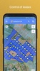
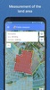
Kadastr UA simplifies land navigation by providing tools to determine the land's location on the ground, retrieve coordinates, and measure areas either by creating a polygon on the cadastral map or tracking the land's contour in real time. You can also send cadastral information via instant messengers, create lists for quick searches, and use navigation features to locate plots effectively. The app integrates orthophotomaps for enhanced cadastral visualization.
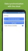
Cloud Services for Land Management
By connecting to its cloud service, Kadastr UA offers additional features for registered users to manage land-related activities. These include comparing field boundaries with cultivated areas, monitoring lease agreements and their durations, and accessing detailed information about shareholders and tenants. These advanced functions enhance the control and oversight of land assets, offering value to individual users and organizations.
Kadastr UA streamlines access to land data while ensuring efficient property management through its user-friendly and highly practical features.
Requirements (Latest version)
- Android 6.0 or higher required
Comments
There are no opinions about Kadastr UA yet. Be the first! Comment